Florida
Satellite images show how Hurricane Milton reshaped parts of Florida coastline
Hurricane Milton lashed Florida’s Gulf Coast with flooding rain and winds of 120 miles per hour that left homes — and, in some cases, full neighborhoods — drenched, muddied and dilapidated. At least 24 deaths have been blamed on the storm, officials confirmed to CBS News.
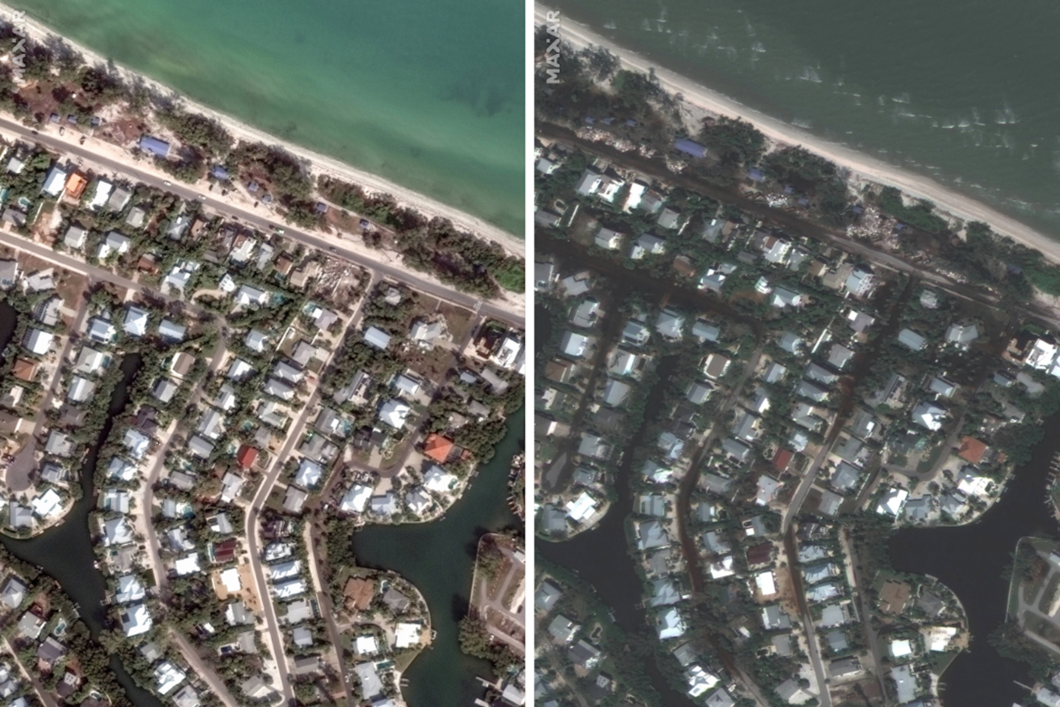
Satellite images illustrate the scope of the damage in coastal communities along the western part of the Florida peninsula, near the Sarasota barrier island of Siesta Key where Milton made landfall Wednesday, Oct. 9, as a powerful Category 3 hurricane.
The images, captured one day after the storm struck the region, show beaches in Siesta Key and Anna Maria Island, another barrier island just north of Milton’s landfall site, darkened and damaged, each riddled with murky sand that appears to push inland toward the surrounding streets and buildings. They appear to the left side of satellite images taken of the same areas before the latest hurricane.
CBS News correspondent Nicole Valdes flew over Siesta Key with the Florida National Guard on Friday, observing vast devastation from above as loose metal and other debris littered the landscape. This area was among the Gulf Coast communities struggling in the wake of back-to-back hurricanes, as Hurricane Helene rammed into the region less than two weeks before Milton arrived.
Anna Maria Island’s beaches remained closed Tuesday, according to the region’s severe weather information center, as did government offices like the island’s chamber of commerce building. In Siesta Key, a boil water notice was still in place and Fisherman’s Haven and Sanderling Road, at the lower edge of the barrier island, did not yet have water restored, Sarasota County officials said.
Another satellite image shows destruction in Clearwater, near Tampa and St. Petersburg, where first responders used high-water vehicles and boats to rescue families who were trapped inside of a local apartment complex.
“We lost everything, I lost everything, there was about 10 feet of water in my apartment right, because I tried to go back in and grab some stuff, and it rising, rising, it was up to my chest,” one man who lives in the complex told CBS News.
Some homes in the nearby Tampa area were almost completely submerged underwater after the storm, while the Hillsborough County Sheriff’s Office conducted dozens of rescues and evacuated more than 135 residents from an assisted living facility.
In Cortez, a fishing village also located along the coast in Sarasota County that was damaged by both Helene and Milton, a satellite shows debris covering roads and the docks that line the waterfront. Both hurricanes battered the historic village, tearing down trees and power lines and reducing buildings to piles of rubble.
The Sarasota Herald-Tribune published additional photos of homes and docks in Cortez that completely collapsed. Milton also ripped off a portion the roof of a condominium in the area, with satellite images taken over that section of the village showing debris scattered on the ground and spread across the area around it.
In Manasota Key, on the western coast of Florida just south of Sarasota, Milton’s storm surge sent massive boulders and at least one boat up the beaches and hurled them into waterfront buildings. Heaps of sand left in the hurricane’s wake were piled 6 feet tall in some places, reported CBS News’ Tom Hanson from the island. Hanson described “a devastating scene” and said the sand resembled “snow drift from a blizzard” that coated both the insides and outsides of homes.
The beach was diminished from Milton, Hanson reported, and Gulf waters were much closer to shore than they had been before the storm.
After Milton knocked out power to some 3 million people in Florida, officials said they expected electricity to be fully restored across the state by Tuesday night. Meanwhile President Biden has authorized an additional $612 million in federal aid to help areas in Florida and North Carolina affected by Milton and Helene.
