Dallas, TX
Car belonging to Dallas woman missing for over a year found, police say

The vehicle belonging to a Dallas woman who has been missing for over a year was found this week, according to police.
The Dallas Police Department said 88-year-old Myrtle Polk’s vehicle was found in the 5600 block of South Lancaster Road, near Five Mile Creek, on Tuesday. Her body was not in the vehicle.
DPD said search teams will deploy in the area to continue the search for Polk.
She was last seen in early June along Indian Creek Trail, driving her Lexus sedan. At the time, a Silver Alert was issued, given her age and medical history, according to the Texas Department of Public Safety.
Myrtle Polk known as a pillar of her community
Polk is a devout member of her church, according to her family. When she didn’t show up for service on June 9, 2024, they said they knew something was wrong.
Also affectionately known as “Mama M” or “Aunt Myrt,” Polk is living with dementia. But her niece Tawana Watson said — as late as the day before — the family did not indicate that anything was wrong.
“She was a very good driver, she knew where she was,” Watson said last June. “I talked to her that Friday [and] she was in her right mind.”
Watson does not believe the matriarch left home on her own.
“She was such a trustworthy person, I believe that Aunt Myrtle met somebody that she trusted, she let them [into her home] and they hurt her,” she continued.
Myrtle Polk is approximately 5-foot-2 and 120 pounds, with white hair and brown eyes. Anyone with information is asked to call 911 or the Dallas Police Department at (214) 671-4268.


The glitz. The glam. The parties. The trips. The allure of high fashion bedazzled with a life of luxury. As with much of the filter-polished nature of social media, all is not as it appears.
For Shaun Balkum, he was living a dream as a high-fashion model with ties to New York and as one of Dallas’ most recognizable faces. The statuesque king of pose was living the high life — or so it seemed. Gracing the runways and booked for Dallas’ marquee fashion shows like DIFFA, Balkum appeared to have it all. Behind closed doors, though, was a past riddled with pain, trauma, suicide ideation and repeated bouts with homelessness. With nowhere to turn and little help, he internalized in the dark, not knowing that many of his peers were also struggling in the same deafening silence.
“Being in the industry for about 15 years now, I’ve been through a lot,” the 34-year-old father of two tells the Observer. “Working in New York at a young age and seeing so many people going down different, dark paths, and the industry just eating them up, was eye-opening for me. A lot of people on the outside will wonder ‘why is this actor on drugs’ or ‘why is there so much suicide within these careers?’ What they don’t realize are the things that these individuals put themselves through. They don’t express or talk about it because they feel like they’re going to be judged at the end of the day by their peers and family.”
Going digital-second
With the dominance of a digital-first culture, creatives today face unprecedented pressure, from constant content demands, online comparison, scrutiny, burnout and isolation. According to a recent study conducted by Creators for Mental Health, an organization that aims to provide resources to digital creators, approximately 1 out of 10 creators say that they’ve experienced suicidal thoughts, with nearly 2 out of 3 creators admitting to mental health challenges such as anxiety and depression. Higher incidence rates rank even more among tenured creators.
According to the National Institute of Health (NIH), suicide continues to be one of the leading causes of death in the U.S. The rate observed among influencers is nearly double the NIH’s reported national average.
And, as online content creation has become an increasingly lucrative path, market oversaturation has fueled added stressors of competition and gig instability.
“There’s an influx of constant competition,” says Jessica Serna, a veteran influencer behind My Curly Adventures. “People don’t realize that it’s not enough just to take good pictures and videos. A lot of times there’s way more going on [behind the scenes] so that you can stand out amongst 100,000 other influencers and creators. I think that’s where the burnout comes – it’s the pressure to stay above in such a competitive field.”
In videos captured across the country, the Dallas-based Serna is all smiles and full of vibrancy as she and her husband traverse turquoise Caribbean waters and dive deep into the ocean blue. Posting daily, she has amassed an audience of over 300,000 Instagram followers sourcing tips on travel, lifestyle and food. Over on TikTok, her reach extends even further with 571,000 followers.
While Serna admits that all that glitters can be gold in the influencer lifestyle, there can also be a dullness when creators face the not-so-glamorous business side of being a creative in order to stand out among a sea of others.
“This has been the most stressful job I’ve ever [had],” Serna says. “I go to sleep thinking about things. I wake up and there’s the pressure of… so many businesses that don’t value your time, or wait two weeks to issue you a paycheck, and then want something the next day, only to ghost you again for another three weeks. Or, a paycheck that you were supposed to get three months ago is now taking its time because it got caught up in something corporate.”
Late paychecks and the pressure to be perfect are only the tip of the iceberg of what creatives experience.
In a recent Youtube confessional titled “being a full time influencer ruined my life,” Dallas creator Ashley Devonna candidly detailed what life was really like for her behind the filters, hashtags and sponsorships. After a 4-year hiatus to recover, the Texas Woman’s University graduate is back, but now on her own terms. Many others are still stuck in the cycle.
Finding community on and offline
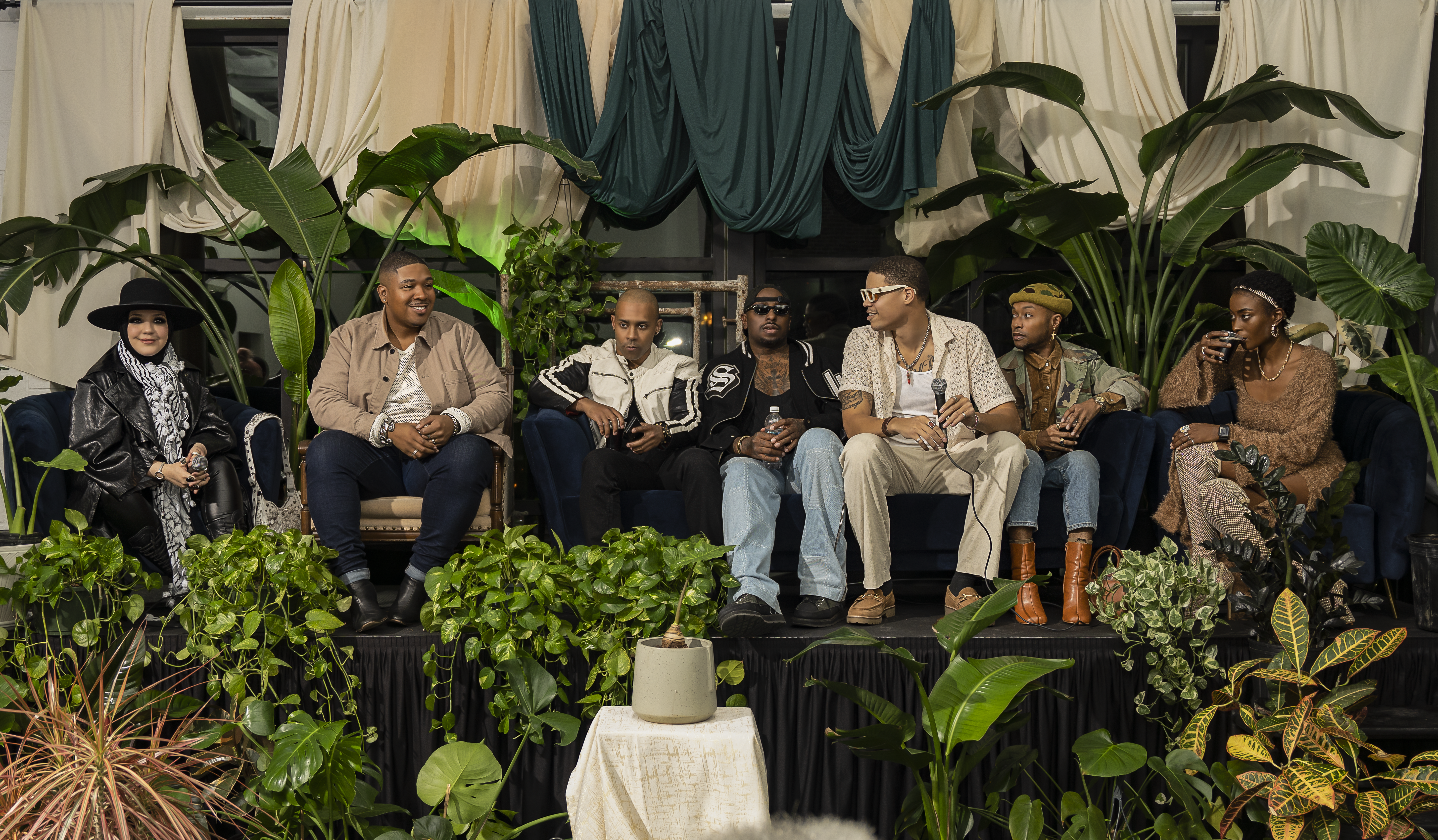
Balkum cites a lack of community and safe spaces for honest reflection, as well as a shortage of affordable mental health resources, as inspiring him to launch his House of Balkum Foundation, a 501(c)(3) initiative stemming from the inadequacies of the fashion industry, and now offering emergency relief assistance, emotional support, community gatherings and mental health and wellness resources. His upcoming event, Saving the Creatives —dubbed the “church for creatives” — will feature an all-star panel of Dallas’ top talent including Celebrity Stylist KJ Moody, Actor and Model Kamen Casey, Photographer Jamie House and others, to discuss the challenges suffocating the industry, but also to provide solutions and support.
“We’re all intertwined in a way, and we all need each other,” Balkum says. “You know, the models need the photographers, and the photographers need the makeup artists, and the makeup artists need the models. At the end of the day, I want creatives to understand that they finally have somebody here for them, and that’s looking after them. For all of the creatives that have felt alone, that have struggled in silence – we hear you. You can talk to us and we’ll provide whatever help that we can for you.”
Dallas startup RM11 is on a similar mission. The creator-first platform was founded by Natasha August and boasts numerous perks that allow creators to own their relationships with their followers, receive fair monetization and build a sustainable business – and, hopefully, a less stressful one.
“Creators are entrepreneurs in every sense of the word,” August says. “They’re building brands, communities, revenue streams and entire businesses around their voice and audience. The more I learned about the creator economy, the more I realized how underserved creators really are. They’re expected to be talent, a marketer, customer support, content strategist, community manager and business owner all at once. I saw an opportunity to build something that gave creators more control, better tools and a more supportive way to monetize directly from their audience.”
Recently, RM11 strategically partnered with both Revive Health Therapy and Creators 4 Mental Health – a major step in its mission to support creator well-being, reduce burnout and build a healthier creator ecosystem through its CreatorCare approach. RM11 creators have access to licensed mental health professionals who specialize in creator-specific stressors, as well as affordable, flexible therapy options, community support and wellness tools to help manage burnout and emotional fatigue.
“One of the biggest misconceptions that the general public has is that creating content is easy or not a ‘real job.’ In reality, creators are running small businesses, often by themselves, while also putting their personality, image and personal life in front of the public,” August says. “There’s also a misconception that if someone has followers or makes money online, they must be confident, happy or unaffected by negative comments and pressure. But creators can experience burnout, isolation, anxiety and emotional exhaustion just like anyone else, sometimes even more intensely because their work is so personal and public.”
According to a 2026 study with data from Social Blade, Texas ranks fourth among the nation’s largest hubs for online influencers, accounting for roughly 8% of the most-followed creators. The state is also home to 1 out of 10 creators ranked in the top 500 of the creator ecosystem. If you want to make it to the top of the creator economy, Dallas is where you come. Therefore, Dallas-based businesses like House of Balkum and RM11 are not only essential but necessary with growing demand.
“Being an influencer is easy, but when something’s easy, and you actually want to be successful in it, that’s when it gets harder than people even realize. I’m extremely grateful for it though,” Serna says. “It’s so funny how something can be so simultaneously amazing and so draining at the same time.”
Saving the Creatives will be hosted by The House of Balkum on Sunday, July 12, at 6:00 p.m. at Four Day Weekend, 5601 Sears Street. Tickets are available for $35.
If you or someone you know is struggling with suicidal thoughts, help is available. You can call or text 988 to reach the Suicide & Crisis Lifeline, or chat via 988lifeline.org for free, confidential support 24/7.

Subscribe to The Y’all — a weekly dispatch about the people, places and policies defining Texas, produced by Texas Tribune journalists living in communities across the state.
Two companies tied to a Dallas investor filed a federal lawsuit to lift a moratorium in an ongoing East Texas water dispute, alleging a groundwater district has illegally blocked their efforts to extract water from beneath land they own.
This is the latest legal action taken in a growing battle over groundwater resources in East Texas.
Kyle Bass, a venture capitalist and owner of Redtown Ranch Holdings LLC and Pine Bliss LLC, is seeking to end a moratorium on large-scale water extraction projects imposed by the Neches & Trinity Valleys Groundwater Conservation District. The lawsuit, filed through Redtown Ranch and Pine Bliss, argues that the conservation district violated the constitutional rights of Bass and his companies by denying access to water beneath the land and also seeks an undisclosed amount of compensation.
Redtown Ranch and Pine Bliss, both funded by Bass’ private equity firm Conservation Equity Management, filed permits with the Neches & Trinity Valleys Groundwater Conservation District to drill 43 water wells across two counties that, when fully operational, could extract billions of gallons of water from the Carrizo-Wilcox Aquifer.
“What we’re trying to do here is just prevent the district from weaponizing its regulatory power to strip my clients of their property rights,” said Mollie Mallory, an attorney with Tillotson Patton, the law firm representing Redtown Ranch and Pine Bliss LLC. “The whole purpose here is just to hold them accountable and to get them to follow their own rules.”
Bass said he hasn’t been treated fairly by the district despite following its rules for years. He said the roadblocks enacted by the district, such as the moratorium, prevented his company from testing the groundwater beneath land he owns.
“This is bigger than just what happened to me,” Bass wrote in a statement to The Texas Tribune. “My lawsuit is about protecting the property rights of all Texas landowners and making clear that government regulators cannot simply change the rules to pick winners and losers.”
The groundwater district had not been served with the new lawsuit as of Wednesday afternoon, said Holli Pryor-Baze of Skelton Slusher Barnhill Watkins Wells PLLC, the attorney representing the groundwater district.
“We certainly disagree with the allegations, but are not prepared to say more than that,” she said.
A board meeting for the district will be held next week, at which time Pryor-Baze said she hoped to have been served and given time to think through the lawsuit.
Battle over water rights
The lawsuit follows a yearslong battle over groundwater access that reached a fevered pitch during the second special session of the 2025 legislative session in August. State lawmakers at the time tried and failed to set a statewide moratorium on projects of this magnitude until the state could study its aquifers to determine how much water is available and how quickly the groundwater supply replenishes.
It all began when Conservation Equity Management purchased thousands of acres in Houston, Anderson and Henderson counties with the intent to drill 43 high-capacity water wells. The latter two counties are represented by a groundwater conservation district that gave initial approvals for the project to move forward because the applications were administratively complete, a legal term meaning they were filled out properly.
The project drew the ire of East Texans, who were already angry at a number of Dallas-area organizations seeking to extract water from the region. But poultry producer Wayne-Sanderson Farms LLC, which has operations in East Texas, sued to stop the project, claiming that the wells would drain the area of its main water source and impact its operations. Wayne-Sanderson Farms uses water from the Carrizo-Wilcox Aquifer for its processing plants and feed mills.
A district judge approved a settlement between the groundwater conservation district and Sanderson Farms and barred the district from approving certain applications until the aquifer could be studied. It also voided the original decision that the applications were administratively complete.
Then, on May 21, 2026, the district adopted a resolution calling for a moratorium on any “new non-exempt groundwater permit applications.” This moratorium prevents the district from taking action on applications for projects that don’t provide water for local use, such as for households, agriculture or local businesses.
The moratorium will end in October or when the district finishes reviewing and updating its rules — whichever is later. The district is in the process of doing so right now, Pryor-Baze said.
Conservation Equity Management sued to vacate the judge’s moratorium, then filed the latest lawsuit to stop the district’s moratorium in federal court in Tyler on July 7.
The goal is to allow Pine Bliss and Redtown Ranch to finish the administrative process as laid out in the district’s bylaws. This would include going through the State Office of Administrative Hearings before beginning operations.
“We would just continue down that road with the hope that we eventually get to do exploratory drilling to see what water is on their land,” Mallory said.
Source link

(Editor’s Note: As part of the preparation for training camp, this series will introduce 25 players who are new to the Cowboys’ roster, rookies and veterans alike. We’ll continue with outside linebacker Tyrus Wheat.)
The 2026 season will mark a homecoming for Wheat, who is now back in Dallas for his second stint with the Cowboys. As an undrafted free agent out of Mississippi State, Wheat signed with the Cowboys in 2023 on the practice squad before quickly being signed to the active roster a few months afterwards.
In his rookie season, Wheat saw a majority of his snaps come on special teams with 197, and only 31 snaps on defense. That would flip in his second season, with 165 snaps on defense and 46 on special teams. Through two years, Wheat played in 20 games and tallied 18 tackles and half a sack before spending a year with the Lions in 2025.
As is true across all levels of football, you can never have enough pass rushers. Wheat gives the Cowboys another pass rusher, who has the added ability to be able to help out on special teams as well as a blocker on kickoffs.
As for how much he’ll be in the defensive rotation, that’ll have to be something he earns in training camp. The Cowboys have some younger pass rushers ahead of him now like Donovan Ezeiruaku and first-round pick Malachi Lawrence, so there’ll need to be some proving done. That said, Wheat is also coming off his best year yet with the Lions. Will it be enough to find a role in the pass rush rotation? Oxnard will give us a good idea of that.
- Wheat played a vital special teams role for the Lions last season, tallying 11 special teams tackles which was the third-most for Detroit in 2025. He played a career-high 215 special teams snaps in order to get to that point.
- Wheat’s one and only season away from the Cowboys thus far in his career saw him play in 15 games for the Lions, where he also tallied a career-high 15 tackles and 1.5 sacks despite only playing 66 defensive snaps.
- After wearing 91 in his first stint with Dallas, Wheat returns to the Cowboys wearing 90 now, which was last worn by defensive tackle Solomon Thomas.
-

 Tennessee2 minutes ago
Tennessee State men’s hockey cancels 2026-27 inaugural season for second straight year
-

 Texas7 minutes ago
Ted Cruz warns Talarico has ‘real chance’ to flip Texas’ U.S. Senate seat
-

 Utah14 minutes ago
Man suspected in 2006 Utah murder left suicide note in Las Vegas jail cell: police
-
 Vermont17 minutes ago
OUTDOOR ACCESS FOR DISABLED IN VERMONT
-
 Virginia22 minutes ago
4 indicted in Virginia double homicide; second victim ID’d as grandmother of 6
-

 Washington29 minutes ago
Washington Commanders are retiring Hall of Famer John Riggins’ No. 44
-

 Wisconsin32 minutes ago
Wisconsin State Patrol rides with truck and bus drivers to spot violations in five areas
-

 West Virginia37 minutes ago
West Virginia town fires entire police force after chief resigns, sergeant alleges evidence room break-in

