Vermont
Spring-like days ahead, but the risk for additional river ice jams and flooding will continue.

BURLINGTON, Vt. (WCAX) – It was a pleasant Sunday with spring-like temperatures, but it also resulted in a few ice jams in rivers, which happened earlier than expected. The Ausable, Mad, Missisquoi and Great Chazy rivers flooded today due to ice jams. These rivers will recede tonight as temperatures get close to, or below, freezing. However, new ice jams may form, and additional rivers may flood on Monday as highs get even warmer. Expect partly sunny skies with highs in the upper 50s to low 60s. The wind may gust as highs as 40 mph. This will continue to support rapid snowmelt, which will run off into rivers and other bodies of water. Remember to never cross any flooded roads, and avoid going near river banks.
The threat for ice jams will continue into Thursday. A backdoor cold front may touch off a few showers on Tuesday, otherwise it will be partly sunny with highs ranging from the 40s north to the 50s and low 60s south. Computer models continue to bring a low pressure system in our area on Wednesday. It’s continuing to look a little warmer, though the heavier rain is now inching farther into Canada. That said, some rain is likely, and high temperatures will be at least in the low 40s, and may reach the 50s in southern parts of the region. Morning rain on Thursday will change to afternoon snow. A few inches accumulation is possible. Early highs in the 30s will fall through the 20s by afternoon, and overnight lows will be in the teens and low 20s, so everything will freeze up.
Friday will start off with some sunshine, then another, weaker system could bring a light rain/snow mix late in the day and overnight. A few inches of snow can’t be ruled out. A return to more seasonable temperatures will happen over the weekend with highs mainly in the mid-30s and lows in the teens and 20s. There’s the chance for snow showers both days, but significant weather isn’t expected.
Copyright 2026 WCAX. All rights reserved.


Louis Arevalo rides his adaptive mountain bike through the trails at Randolph Town Forest during an adaptive assessment on Thursday, June 25. Nick Bennette, with the Vermont Mountain Bike Association, rides behind.
Zoe McDonald/Vermont Public
hide caption
toggle caption
Zoe McDonald/Vermont Public
Mountain bike enthusiasts have been working for years on an ambitious 485-mile, multi-use trail called The Velomont that will span the length of the state.
When finished, the collaborative project will knit together existing trail networks, connect 27 communities and include huts and hostels for overnight stays.
New trail construction is finally ramping up after years spent on permits, plans and public input. And organizers say they want to make it as user-friendly as possible.
“For us, it’s not a huge lift to just be mindful when we’re trying to build trail or improve trail to think about the adaptive rider,” said Angus McCusker, the Velomont trail director with the nonprofit Vermont Huts and Trails.
McCusker is referring to the growing number of disabled athletes who mountain bike with specially designed equipment.
“The challenge,” said McCusker, “is we’re connecting to existing trail networks that were never intended for adaptive bikes. So, where we can, we’re trying to do adaptive assessments.”
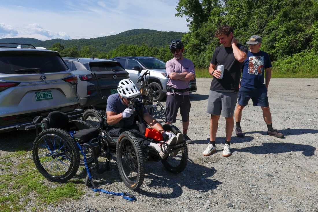
Louis Arevalo, left, straps into his adaptive mountain bike and chats with Jeff Dickson of the Vermont Mountain Bike Association, Angus McCusker with Vermont Huts and Trails, and volunteer Thatcher Hinman (all from left) ahead of a trail accessibility assessment in Randolph, Vermont, on Thursday, June 25, 2026.
Zoe McDonald/Vermont Public
hide caption
toggle caption
Zoe McDonald/Vermont Public
Louis Arevalo of Essex Junction is one of several adaptive athletes helping with that, most recently on some slightly overgrown single track trails in Randolph, a central Vermont town nestled along the eastern edge of the Green Mountains.
Arevalo pedals with his hands. He rides an electric powered recumbent-style three-wheeler that sits low to the ground. His service dog Azul chases along nearby.
“Once you realize what these bikes are capable (of) or this equipment actually opens up, it kind of blows your mind,” he said.
Arevalo was paralyzed in a skiing accident six years ago. Being able to get back on the trails has been a game changer, he said smiling.
“There’s a reason we live in the Green Mountain state. It’s because we like to get outside…you know, seeing the squirrels and chipmunks and birds… I mean, it’s life.”
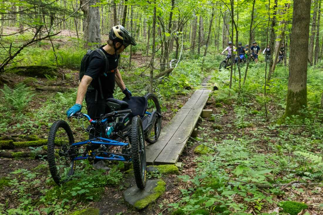
Nick Bennette, of the Vermont Mountain Biking Association, guides an adaptive bike over a narrow bridge, pointing out that other adaptive riders may have trouble getting across.
Zoe McDonald/Vermont Public
hide caption
toggle caption
Zoe McDonald/Vermont Public
But adaptive rigs like Arevalo’s are wider and heavier than regular mountain bikes, and not all trails are user-friendly.
Nick Bennette, who was testing a different type of adaptive bike, got hung up on several tight turns.
“It’s helpful to have different kinds of adaptive bikes on these tests because they all handle a little differently,” he said.
Bennette is executive director of the Vermont Mountain Bike Association, another nonprofit spearheading efforts around the Velomont. He and others involved in the assessment are taking detailed photos and notes on ways to make the trails more accessible.
“Just scalloping out a bit of material on the outside of that corner,” said Bennette, pointing to the area the bike got caught. “That will allow adaptive bikes to make that corner without really changing the way the trail rides.”
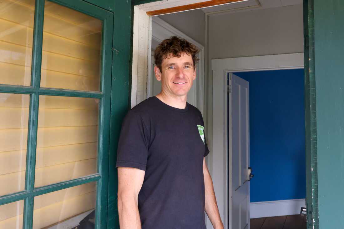
Angus McCusker with Vermont Huts and Trails is working to create accessible accommodations along the Velomont Trail, including a multi-group space in Randolph and a hut in Chittenden that has been outfitted with accessibility in mind.
Zoe McDonald/Vermont Public
hide caption
toggle caption
Zoe McDonald/Vermont Public
Contractors are also trying to reduce barriers at the trail’s overnight accommodations. This summer, contractors are building a new ADA accessible hostel in downtown Randolph.
And two remote huts along the trail will have locked sheds with off-road wheelchairs so bikers don’t have to haul their own.
At the Chittenden Brook Hut, McCusker highlighted a new ramp and wider driveway.
“So if you’re an adaptive rider, you can imagine rolling right up here and you can transfer to your chair that’s available here, and then roll down the ramp and go down to the fireplace, to the privy, to make your meal,” he said.
Louis Arevalo stayed at the hut last summer with other adaptive riders — his first camping trip since his accident.
“There was a babbling brook right there…and it was really refreshing to have easy access to a beautifully built hut that was easy to navigate, and then have these world-class trails right out the door,” he said. “And with these Velomont trails, I can actually plan a hut-to-hut trip with other people.”
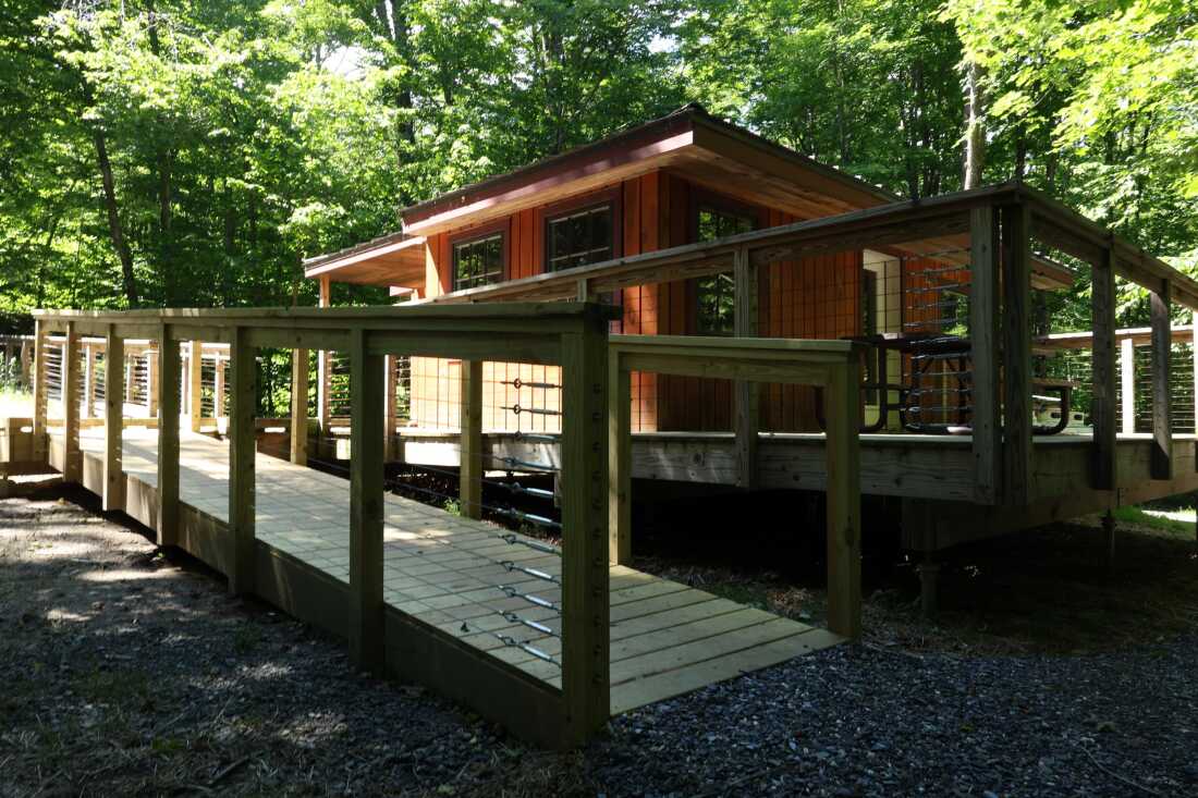
The Chittenden Brook Hut includes accessible ramps, storage for adaptive bikes and specialized off-road wheelchairs for visitors.
Zoe McDonald/Vermont Public
hide caption
toggle caption
Zoe McDonald/Vermont Public
Jeff Alexander is counting on it. He’s director of strategic partnerships with Vermont Adaptive Ski and Sports, a nonprofit that helps people with disabilities access outdoor recreation.
An economic impact analysis the group commissioned estimates their programming generated more than $10 million last year.
“So the adaptive community has money, they travel, they want to travel and they want to play with everybody,” Alexander said. “We just need to level the playing field so that everyone can play together.”
Powerball, Mega Millions jackpots: What to know in case you win
Here’s what to know in case you win the Powerball or Mega Millions jackpot.
Just the FAQs, USA TODAY
The Vermont Lottery offers several draw games for those willing to make a bet to win big.
Those who want to play can enter the MegaBucks and Lucky for Life games as well as the national Powerball and Mega Millions games. Vermont also partners with New Hampshire and Maine for the Tri-State Lottery, which includes the Mega Bucks, Gimme 5 as well as the Pick 3 and Pick 4.
Drawings are held at regular days and times, check the end of this story to see the schedule.
Here’s a look at July 8, 2026, results for each game:
Winning Powerball numbers from July 8 drawing
12-29-37-43-55, Powerball: 18, Power Play: 4
Check Powerball payouts and previous drawings here.
Winning Gimme 5 numbers from July 8 drawing
01-05-23-36-38
Check Gimme 5 payouts and previous drawings here.
Winning Pick 3 numbers from July 8 drawing
Day: 0-1-3
Evening: 2-4-0
Check Pick 3 payouts and previous drawings here.
Winning Pick 4 numbers from July 8 drawing
Day: 3-9-5-9
Evening: 9-2-0-9
Check Pick 4 payouts and previous drawings here.
Winning Megabucks Plus numbers from July 8 drawing
12-15-23-27-40, Megaball: 03
Check Megabucks Plus payouts and previous drawings here.
Winning Millionaire for Life numbers from July 8 drawing
16-18-43-48-50, Bonus: 01
Check Millionaire for Life payouts and previous drawings here.
Feeling lucky? Explore the latest lottery news & results
Are you a winner? Here’s how to claim your lottery prize
For Vermont Lottery prizes up to $499, winners can claim their prize at any authorized Vermont Lottery retailer or at the Vermont Lottery Headquarters by presenting the signed winning ticket for validation. Prizes between $500 and $5,000 can be claimed at any M&T Bank location in Vermont during the Vermont Lottery Office’s business hours, which are 8a.m.-4p.m. Monday through Friday, except state holidays.
For prizes over $5,000, claims must be made in person at the Vermont Lottery headquarters. In addition to signing your ticket, you will need to bring a government-issued photo ID, and a completed claim form.
All prize claims must be submitted within one year of the drawing date. For more information on prize claims or to download a Vermont Lottery Claim Form, visit the Vermont Lottery’s FAQ page or contact their customer service line at (802) 479-5686.
Vermont Lottery Headquarters
1311 US Route 302, Suite 100
Barre, VT
05641
When are the Vermont Lottery drawings held?
- Powerball: 10:59 p.m. Monday, Wednesday, and Saturday.
- Mega Millions: 11 p.m. Tuesday and Friday.
- Gimme 5: 6:55 p.m. Monday through Friday.
- Lucky for Life: 10:38 p.m. daily.
- Pick 3 Day: 1:10 p.m. daily.
- Pick 4 Day: 1:10 p.m. daily.
- Pick 3 Evening: 6:55 p.m. daily.
- Pick 4 Evening: 6:55 p.m. daily.
- Megabucks: 7:59 p.m. Monday, Wednesday and Saturday.
- Millionaire for Life: 11:15 p.m. daily
What is Vermont Lottery Second Chance?
Vermont’s 2nd Chance lottery lets players enter eligible non-winning instant scratch tickets into a drawing to win cash and/or other prizes. Players must register through the state’s official Lottery website or app. The drawings are held quarterly or are part of an additional promotion, and are done at Pollard Banknote Limited in Winnipeg, MB, Canada.
This results page was generated automatically using information from TinBu and a template written and reviewed by a Vermont editor. You can send feedback using this form.
Vermont
Poll: Most young Vermonters say they’re likely to leave state amid affordability concerns – VTDigger

Theo Wells-Spackman is a Report for America corps member who reports for VTDigger.
Nearly two-thirds of Vermonters ages 18 to 34 say they’re likely to leave the state within five years in search of adventure or a cheaper place to live, according to a poll from the University of New Hampshire.
Overall, the poll estimated that 86% of Vermonters find the state at least somewhat unaffordable.
“The issue of affordability has been a very important thing across New England,” said UNH political science professor Andrew Smith, who runs the institution’s survey center. The poll, released Tuesday, includes response data for five New England states, excluding Maine.
In general, the survey found, most residents say Vermont is a good place to live — or even a great one.
Nevertheless, about 40% of Vermonters of all ages want to leave the state, according to the report from Smith’s team. Housing prices and other cost-of-living concerns are the foremost drivers of the trend, researchers found, followed by tax rates. Connecticut and Rhode Island showed similar overall rates of desired departure.
Among young people, though, Vermont’s numbers stand out.
Smith’s research found that 63% percent of Vermonters between 18 and 34 say they’re somewhat or very likely to move out of the state in the next five years. That’s a much higher rate of planned departure than in any other state surveyed. Responses varied from 28% in New Hampshire to 44% in Connecticut.
But according to Smith, New England often sees a beneficial “boomerang effect”: former residents eventually returning to their home states, often as higher earners.
In a Wednesday press conference, Gov. Phil Scott said that although he hadn’t seen the poll, he wasn’t surprised by reports that many Vermonters are considering a move.
“I think there’s a lot of frustration out there,” he said. “We have a lot of work to do to make Vermont the affordable state that these folks need.”
About half of young Vermonters who said they want to move away cited the cost of living as a primary reason, while roughly as many said they were looking for a “new adventure or more excitement.” By contrast, less than a quarter of those older than 64 foresee leaving, according to the poll.
Outmigration of young people could worsen the state’s existing workforce shortage, according to Kevin Chu, who leads the research nonprofit the Vermont Futures Project. Scott’s administration has made workforce development a priority in light of what his office called a “growing demographic crisis.”
Chu added that by design, services such as public education and healthcare are supported disproportionately by working households that tend to pay higher taxes and insurance premiums. When the base of income earners shrinks, the problem can then intensify for those bearing the brunt of rising costs, he added.
“There’s a demographic reality in which the economic burden is being shouldered by a small and shrinking pool of young working-age people,” Chu said.
Tuesday’s poll also indicated that Vermonters who have completed more education say they’re less likely to leave the state. For Chu, that’s likely because such households tend to earn more — and also because they tend to be older.
Julie Lowell, deputy director of the Montpelier research nonprofit Public Assets Institute, offered a grain of salt in relation to Tuesday’s report. While migration is crucial to keep track of, Vermont’s overall population turnover tends to be about 5% or less each year, she said. And although the state does have an unusual number of young people intending to leave, that age group is always the most mobile in any study, she said.
In recent years, more of Vermont’s older population has possessed more wealth to contribute to public services, Lowell added. For example, she said, her organization has found that more Vermonters aging out of the workforce has not appeared to decrease state tax revenues in recent years.
But it’s true that many Vermonters are struggling to make ends meet, she said. The state’s lowest earners have seen low wage growth in relation to other New England states, she said, and basic needs are getting harder to cover.
“We’re seeing prices, in large part driven by housing and healthcare, really outpacing our increases in household incomes,” Lowell said. “Many people are feeling insecure.”
-

 News8 minutes ago
Trump fires last members of election commission, inciting fears of midterm ‘chaos’
-

 Los Angeles, Ca1 hour ago
California teen e-biker baiting police to chase tracked by drone, arrested
-

 Detroit, MI2 hours ago
Our picks for state\nSenate from Wayne Co. | Endorsements
-

 San Francisco, CA2 hours ago
Man reported missing in San Francisco
-

 Dallas, TX2 hours ago
How to buy France World Cup semifinal soccer tickets in Dallas
-

 Miami, FL2 hours ago
Miami-Dade Schools names six semifinalists for superintendent
-

 Boston, MA2 hours ago
Lawsuit: ICE detained East Boston father despite legal status
-

 Denver, CO2 hours ago
Victor Marx wins GOP primary for Colorado governor, defeating veteran lawmaker after unorthodox campaign

