Pittsburg, PA
Pittsburgh’s unsettled weather pattern continues into this coming week

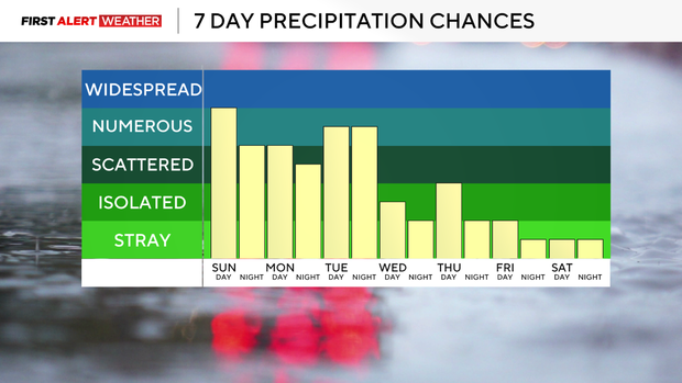
Rainfall totals have been quite healthy in spots over the last 24 hours. Most locations in our viewing area received 0.25″ to locally over 0.75″ with more opportunities to add on to the existing event totals through the next several days.
WEATHER LINKS:
Current Conditions | School Closings & Delays | Submit Your Weather Photos
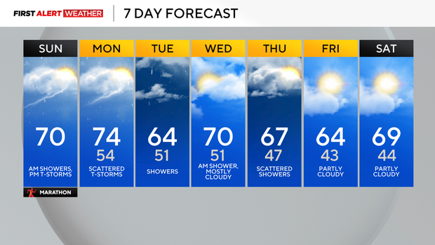
Just before sunrise Sunday, most of Western Pennsylvania and Northern West Virginia was under a lull in the most widespread rain with areas of drizzle and scattered showers around. Radar shows the next wave of rain showers lifting north through West Virginia and it will be moving through Western Pennsylvania from around sunrise to roughly mid morning (10-11 a.m.), so for those of you participating in the marathon, there will be at least some rain to contend with, but no driving downpours or thunderstorms expected—that comes later today.
In between this morning’s disturbance and the next “spoke” of energy rotating around a cutoff low to the west, some dry air may sneak in and allow for some breaks in the cloud cover from Pittsburgh and points southwest. Areas that see the most and longest duration of clearing will build up some potential energy that will support scattered to numerous thunderstorms this evening, and even an isolated severe storm cannot be ruled out.
The timing for the next wave of storms would be after 3 p.m. through roughly 9-10 p.m. The main threats with any storm to turn severe would be gusty winds and hail, and a funnel cloud or brief/weak tornado cannot be ruled out.
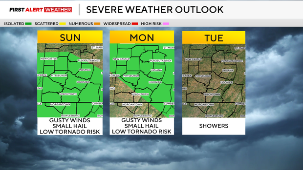

This same pattern will be on repeat for Monday, except we will likely start the day with patchy dense fog, then partial clearing with scattered to numerous thunderstorms developing in the afternoon. Highs will be in the mid-70s.
Tuesday will trend to be an overcast day with scattered to numerous rain showers as the upper level low and its saturated column of air move overhead. Some lingering rain showers are expected Wednesday morning before this system finally starts to exit to the northeast.
On its heels, however, models are in moderate agreement that another wave of low pressure and a cold front to move into the region by Thursday. This front will carry a chance of showers, especially over our southern counties.
Following the front, cooler weather looks to settle in toward the back half of next week and the following weekend with highs in the mid to upper 60s and lows in the low to mid 40s, which is actually not terribly far below normal.
There’s a chance that another cutoff low may develop over the Northeast, and if that were to be the case, we would have to trend up on the cloud cover and lower temperatures a bit into next weekend, so adjustments to the forecast are possible in the upcoming week.
Stay up to date with the KDKA Mobile App – which you can download here!