Pennsylvania
Final Call Snowfall Forecast for Sunday’s Snowstorm in Pennsylvania

Winter Storm Warnings and Winter Weather Advisories have been issued by the NWS ahead of our short, but potent snowstorm that is on tap for Sunday. Travel will be dangerous Sunday afternoon and evening in most of the state, and it’ll be one of those days to stay inside and watch a snowy Eagles playoff game.
On the graphic below, you will also see Extreme Cold Watches in Western and Northern PA, issued for Monday to Thursday. There is a strong chance schools will be closed for multiple days this coming week due to the threat of frostbite. We will have those details on Sunday!
Snowstorm Timing
Light snow will move into Southern PA from SW to NE on Sunday morning between 9 – 11 AM. The leading edge of snow will push northeast towards I-80 around lunchtime, meanwhile snow will become heavy in Southern and Eastern Pennsylvania.
Heavy snow will continue generally along and east of the I-81 corridor through Sunday afternoon, while light to moderate snow falls near I-99 and Route 15 in Northern PA. As we head into the evening, snow will lighten up from SW to NE and begin to move out.
This will be a fluffy snow, which means it won’t be too exhausting to shovel. However it also means as winds kick up behind the storm for the next few days, snow drifts over roadways will be a concern along with the life-threatening cold temperatures.
Below are timing charts for this storm. If you do not see your location, please find the nearest city or area.


Below is the latest future radar from the Hi-Res Rapid Refresh Model as of Saturday evening, lining up with the timing shown above. You will also notice a small chance of mixing in Philadelphia, as well as lake effect snow in NWPA.

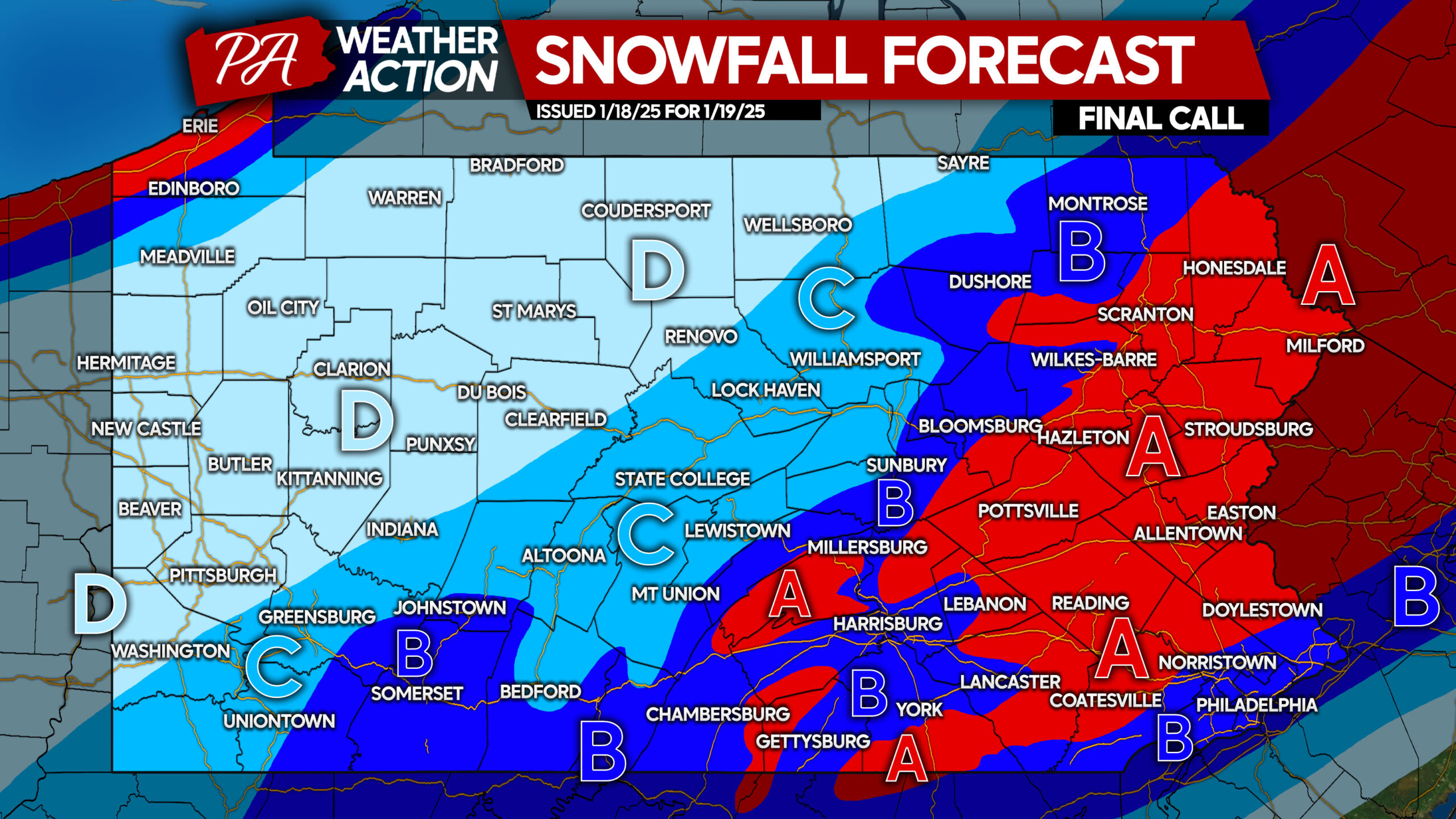
Area A: Snowfall accumulation of 6 – 8″ expected. Snow-covered roads will cause dangerous travel conditions soon after snow begins through early Monday morning.
Area B: Snowfall accumulation of 4 – 6″ anticipated. Roads will become snow-covered, making travel inadvisable after snow starts into early Monday AM.
Area C: Snowfall accumulation of 2 – 4″ expected. Snow-covered roads will lead to very poor travel conditions.
Area D: Snowfall accumulation of 1 – 2″ anticipated. Secondary roads may be covered by snow, causing slippery travel.
Be sure to share this forecast with friends and family!
More details on the harsh cold next week will be posted Sunday.
Pennsylvania
Continued Legacy: Central Pennsylvania Auto Auction gears up for 25th anniversary of Classic Car Auction

MILL HALL — This weekend, Central Pennsylvania Auto Auction, 41 Airstrip Dr., Mill Hall, will celebrate the 25th anniversary of its annual Classic Car Auction, welcoming thousands of collectors, buyers and enthusiasts from across the country for two days of bidding, entertainment and celebration. For President Doug Miller, however, the milestone represents far more than classic automobiles.
“It’s kind of like a milestone for us,” Miller said, as he reflected on the anniversary. “Because it’s my dad that started this. We lost him three years ago, and obviously we’re continuing on his legacy and things that he wanted to do. It’s not about the vehicles, it’s not about the auction. It’s just more of continuing on what he would want.”
The collector car event is an extension of the business founded by Miller’s father, Grant, and mother in 1987. While the company is preparing to celebrate 39 years of its weekly dealer-only auto auction in August, the annual collector auction has become a destination event in its own right.
“My father started the company 39 years ago in 1987,” he said. “Over the years, as our sales sort of grew, my father took an interest in antique and collector cars. He would go to other auctions and buy cars and thought, ‘Geez, we have our facility here. We should maybe try and do one of our own.’ So 25 years ago, we set up our collector car auction that we hold, and it’s always been the third weekend in July ever since.”
This year’s event will feature more than 400 collector vehicles crossing the auction block over two days, along with vintage memorabilia, gas pumps, signs, mini bikes and other automotive collectibles.
While many of the consignments come from Pennsylvania and neighboring states, Miller said the auction’s reputation now stretches far beyond the region.
“We have customers that come from all across the United States,” he said. “The consignments come out of Pennsylvania and the bordering states — New York, New Jersey, Ohio, Maryland, Delaware. We have customers that have sent cars from as far as North Carolina.”
The auction has also become much more than a place to buy and sell classic vehicles.
Thursday evening opens with a complimentary cocktail reception featuring live entertainment at Grant’s Place. The auction begins Friday morning with memorabilia before moving to the collector cars. Friday evening includes a VIP gala with dinner, live music and fireworks.
“It’s like a celebration, not just an auction,” Miller said. “We like to try to provide some entertainment because we’re obviously in a rural area and it gives the people something to do after the sale’s over.”
The event also brings a significant economic boost to the surrounding community. Hotels fill with visitors, restaurants welcome out-of-town guests and dozens of RV owners make a weekend of the festivities.
“We’ll have upwards to probably a couple thousand people come through our doors over the next three days,” Miller said. “We’ll probably have 30 or 40 RVs across the street that people will set up and spend the weekend camping in our parking lot.”
The celebration comes after months of planning by a team of employees who transform the auction grounds in just a matter of hours. Following Thursday’s regular dealer auction of roughly 750 vehicles, staff immediately begin clearing the lot and staging the hundreds of collector cars.
“We go home to shower and come back basically,” Shanan Miller said with a laugh. “We’re here around the clock.”
Behind the scenes, nearly 100 employees — full-time and part-time — work together on auction days to keep the operation running smoothly.
“It wouldn’t be possible without our employees,” he said. “It’s a lot of work.”
He added that once the first gavel falls Friday morning, everything falls into place.
“Once Friday morning at 9 o’clock hits, it just sort of takes off,” he said. “It’s on autopilot for the weekend.”
For Doug, the family business has always been about more than selling vehicles.
After graduating from high school in 1989, he briefly attended college before realizing his passion remained at the auction his father had built. His father insisted he learn every aspect of the business from the ground up.
“He said, ‘If you think for one minute that you’re going to leave school and come here and sit behind a desk and direct orders, that’s not happening,’” Doug recalled. “He said, ‘You’re going to learn every function in this business.’”
So he did.
He started detailing cars, transporting vehicles, picking up litter and plowing snow before eventually moving into management.
“And I still do,” he said with a smile. “If I need to go pick up a load of cars, I can do it.”
Today, he is passing those same lessons on to his son, Jack Miller, who joined the business full time after the passing of his grandfather.
“I’m doing the same thing with my son, Jack,” Doug said. “He started where I did too.”
In following in their footsteps, Jack hopes to preserve what generations before him have built.
“I just want to continue what my dad has done and my grandfather before him,” Jack said. “Do as good of a job as they’ve done and provide the same level of service that they’ve shown me to provide.”
He believes the relationships built over decades are what keep customers returning.
“I see how it makes our customers feel,” he said. “I believe that’s a huge part of what brings them back here, week after week if it’s for the regular sale, or every year for the classic auction. Just providing good service and working hard — it feels good to work hard and see a positive end result.”
Doug agreed that philosophy remains the cornerstone of the business his father founded nearly four decades ago.
“One thing my dad taught me is that you need to surround yourself with good people,” he said. “Whether it’s customers or employees, that’s what makes you successful.”
That commitment to service extends to everyone who visits the auction.
“We’re very customer-service driven,” Miller said. “You could sell popsicles, you could sell cars or whatever. It’s all about taking care of your customer. That’s what’s going to get them to come back.”
As Central Pennsylvania Auction celebrates 25 years of its Classic Car Auction, the event stands as both a showcase of automotive history and a tribute to the family legacy that continues to drive it forward.
For the Miller family, every collector car that rolls across the auction block is another chapter in a story that began with one man’s dream in 1987– and one they hope will continue for generations to come.

Pittsburgh sees unhealthy air quality from Canada, MN wildfire smoke
Wildfire smoke caused Pittsburgh’s air quality to deteriorate, prompting a code red air quality alert.
Pittsburgh was under a code red air quality alert on Thursday, July 16 as wildfire smoke from Canada and Minnesota settled across the city.
The city’s air quality was expected to deteriorate as smoke concentration at ground level increased throughout the day, with the day’s overall air quality forecast as unhealthy due to fine particles carried in smoke, according to Pennsylvania Department of Environmental Protection.
Here’s what to know about Pittsburgh’s air quality.
What’s the air quality in Pittsburgh today?
The morning of July 16, the air quality was moderate, with an Air Quality Index reading of 55, according to AirNow. But it was expected to hit unhealthy levels later in the day, with the overall daily air quality anticipated to reach dangerous levels with an AQI of 175, prompting Pennsylvania Department of Environmental Protection to issue a Code Red air quality alert. The alert is based on the day’s expected overall air quality and not individual hour-to-hour readings.
Smoke was likely to continue to impact Pittsburgh into the weekend, with a forecast overall daily AQI of 140 on July 17, with the state department of environmental protection issuing a Code Orange air quality alert. This indicates that the air quality may be unhealthy for sensitive groups.
July 18 was likely to see improved conditions, with moderate air quality.
What does a Code Red air quality alert mean?
A Code Red air quality alert indicates that the overall air quality within a day is likely to be unhealthy, with an AQI reading of 151 to 200.
Because the alert is based on the overall air quality for the day, there may be periods of time with better air quality. It’s a good idea to check the current air quality before going outside.
If you have to go outside while the AQI is at unhealthy levels, AirNow recommends avoiding strenuous activities or limiting your time outdoors. It may be a good idea to move outdoor activities indoors.
Pennsylvania Department of Environmental Protection also encouraged residents to avoid using gas-powered lawn and garden equipment, reducing the use of fireplaces or wood stoves and avoiding the open burning of leaves, trash or other materials in an effort to reduce fine particulate matter air polution.
What does a Code Orange air quality alert mean?
A Code Orange air quality alert means that the overall air quality within a day is likely to be unhealthy for sensitive groups, with an AQI reading between 101 to 150.
Those with lung disease, older adults, children and teens should reduce their exposure by engaging in less strenuous activities or limiting their time outdoors when the current air quality is at its worst, according to AirNow.
Wildfire smoke impacting Pittsburgh’s air quality
There were more than 830 wildfires burning in Canada as of July 15, with over 100 considered out of control. Many of the fires impacting the Northeast’s air quality were in Ontario and Minnesota.
Smoke from the wildfires hit Pennsylvania on the evening of July 15, causing hazy skies in Pittsburgh. Conditions were expected to worsen on July 16 as more smoke entered the area, with smoke likely to linger through July 17.
Is Pittsburgh under a heat advisory?
While Pittsburgh was under a heat advisory on July 15, the advisory was no longer in effect on July 16. The high on July 16 was forecast at 93, though temperatures could possibly fall several degrees because of smoke cover, according to the National Weather Service.
Brandi D. Addison and Karina Zaiets contributed to this report.
Finch Walker is the Pittsburgh Connect Reporter for the USA TODAY Network. Contact Walker at FWalker@usatodayco.com. Instagram: @finchwalker_. X: @_finchwalker.
Pennsylvania
Fifth Time’s The Harm: Pennsylvania Gov. Shapiro Again Signed A Budget With No Money For Transit — Streetsblog USA

Another year, another blow to Pennsylvania transit riders.
Keystone State Gov. Josh Shapiro signed the annual budget into law last Sunday, and for the fifth year in a row, public transportation has been left to financially starve. The approved budget contains no funding for transit operations, continuing a streak that forces every agency to scrounge for its own money, to varying degrees of success.
“We’ve been left out for far too long,” remarked Connor Descheemaker, Statewide Campaign Manager for Transit for All, PA! The organization rallied transit riders to send more than 50,000 letters to state representatives and the White House-eying governor calling for transit funding, reaching every legislative district in Pennsylvania.
Those calls went largely unanswered. Riders in Lehigh Valley are now bracing for route eliminations and trip cancellations, despite already paying increased fares. Lancaster County paratransit riders will pay more as well, beginning next month.
Low-income, disabled, and rural Pennsylvanians will lose access to jobs, healthcare, and loved ones. That reality hasn’t stopped their governor from declaring victory.
In a speech at last week’s budget signing ceremony, Shapiro uttered a total of three words about the state-sponsored mobility crisis: “There’s more I want to do – like raising the minimum wage, funding mass transit, and expanding access to affordable housing,” he said.
Shapiro seems to understand the need for well-funded transit. Last year, he sent $220 million to Philadelphia to boost SEPTA’s barren maintenance fund following a series of onboard fires.
One-time relief won’t keep buses running, though.

Shapiro has failed, and failed, and failed again to pass his landmark transit policy. His initial proposal would increase the share of sales tax revenue going to public transit by 2 percent. The blame isn’t all his: Even after he watered down his proposal to a 1.75-percent increase, statehouse Republicans failed to support it.
Even if it had succeeded, it’s too little, too late: The sales tax change would still be $92 million short of the $384 million that Transit for All, PA! estimates is needed to prevent further service cuts in public transportation across the state.
Transit for All, PA! has previously lobbied for its legislative package, which would have increased taxes on car rentals and leases, and raised a new tax on ride shares.
Like Shapiro’s plan, that failed, too.
“The General Assembly has deferred action to invest fully in public transit,” state Sen. Nikil Saval (D-Philadelphia), who had authored the ride share component of the legislative package. “Despite the continued activation and involvement of tens of thousands of Pennsylvanians … we will once again face this issue in 2027.”
Pennsylvania’s last semblance of adequate transit funding ended in 2021 with the expiration of Act 89. The 10-year allocation covered statewide transportation expenses, including roadway maintenance and transit operations.
As soon as Act 89 money dried up, agencies turned to Covid relief grants to stay afloat. Those grants, provided through the American Rescue Plan, ended in 2024. Several agencies have gone so far as to pillage their own fixed-route budgets to continue federally mandated paratransit services.
Call it luck, a Band-Aid, or a bad omen; riders on Philadelphia’s SEPTA and Pittsburgh’s PRT are momentarily safe from service cuts and fare hikes. Following last year’s budget disaster, Shapiro permitted the two agencies to raid their own maintenance funds to temporarily pay for operations.
Now, both are pausing upgrades, deferring basic maintenance, and reckoning with the realities of operating – but not fixing – a large-scale transit system.
State highways, on the other hand, received $775 million in new funding from Shapiro’s budget deal.
Transit advocates in Pennsylvania are shifting strategies to preserve essential transit services. A June decision by the Pennsylvania Supreme Court, allowed slot machines to be taxed at a higher rate.
Both Democrat and Republican lawmakers have shown interest in using revenue from the so-called “skill games tax” to fund transit. The legislature must agree on a tax rate and structure, but declined to do so before finalizing the budget.
“Anytime that there is a discussion of new revenue in Pennsylvania, it needs to include public transportation,” Descheemaker said. “We are losing public transportation actively, right now in Pennsylvania. Public transportation needs to be at the center of those conversations.”
-
 Lifestyle8 minutes ago
‘I Want You to Be Happy’ takes on modern-day dating
-

 Technology20 minutes ago
Apple’s plot to crush OpenAI
-

 World26 minutes ago
Leaked Iran report finds record public anger as regime focuses on holding power
-

 Politics32 minutes ago
White House dishes out new election security jab over Olive Garden’s pasta pass ID policy
-

 Health38 minutes ago
Doctors warn your ‘stomach bug’ may actually be a parasite that’s harder to detect
-

 Sports44 minutes ago
AEW star Kenny Omega blasts social media user over Charlie Kirk comment
-

 Technology50 minutes ago
New bank scam laws could stop suspicious payments
-
 Business56 minutes ago
Environmental groups press to halt Imperial Valley lithium venture

